
Langues:

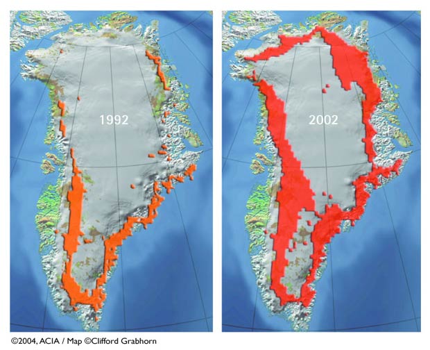
Melt of the Greenland Ice SheetGreenland Ice Sheet Melt Extent: Seasonal surface melt extent on the Greenland Ice Sheet has been observed by satellite since 1979 and shows an increasing trend. The melt zone, where summer warmth turns snow and ice around the edges of the ice sheet into slush and ponds of meltwater, has been expanding inland and to record high elevations in recent years. When the meltwater seeps down through cracks in the ice sheet, it may accelerate melting and, in some areas, allow the ice to slide more easily over the bedrock below, speeding its movement to the sea. In addition to contributing to global sea-level rise, this process adds freshwater to the ocean, with potential impacts on ocean circulation and thus regional climate.  Source : ACIA Impacts of a Warming Arctic: Arctic Climate Impact Assessment Publication apparentée :
Other Figures & Tables on this publication : Observed Arctic Temperature, 1900 to Present Observed sea ice September 1979 and September 2003 Projected Vegetation, 2090-2100 Arctic Thermohaline Circulation Projected Arctic Surface Air Temperatures Projected opening of northern navigation routes Factors influencing UV at the surface 1000 years of changes in carbon emissions Projected Surface Air Temperature change 1990-2090 |